
Real Time Fire
Moving maps of wildfires - from aircraft to your browser in 5 minutes.

Overview
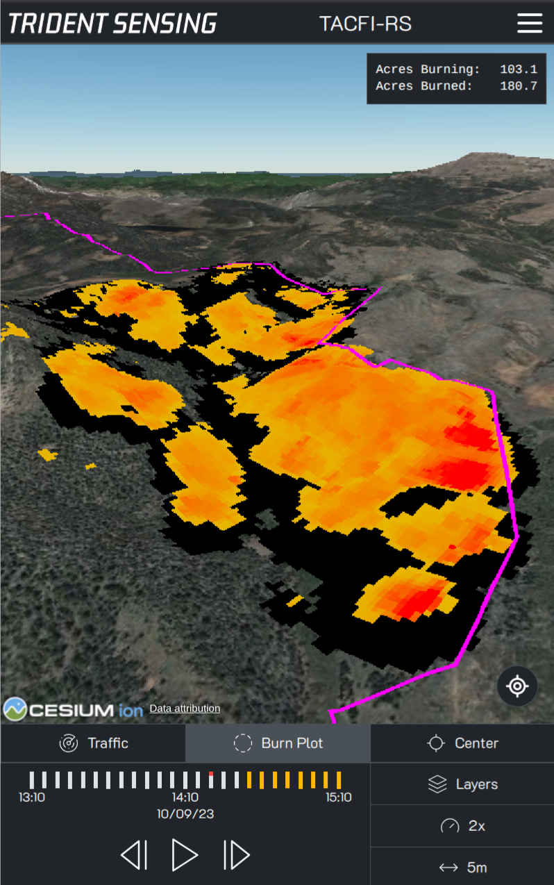
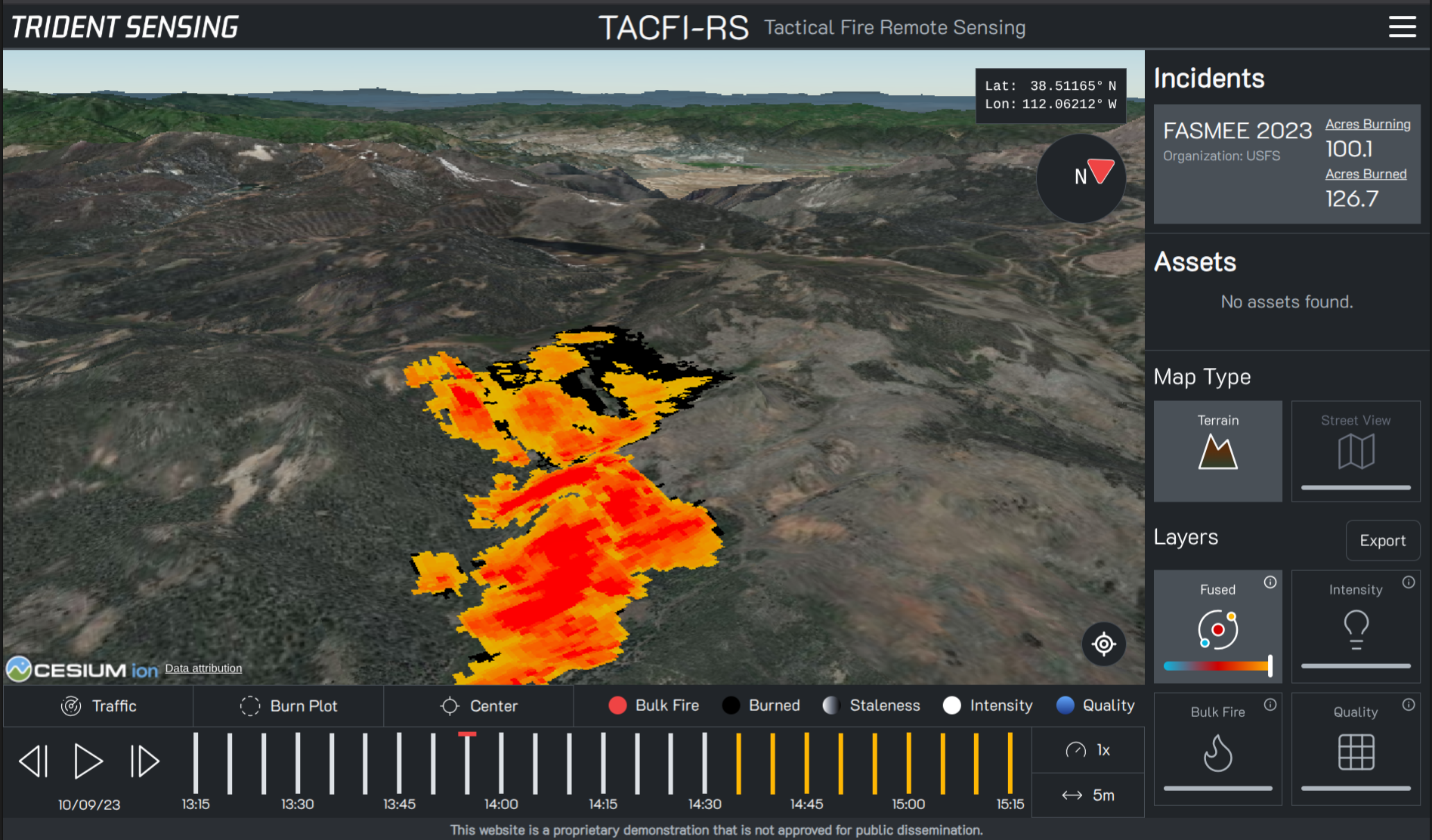
A complete wildfire mapping system.
TACFI-RS tells you where the fire is, where the fire has been, and where it is going, all within 5 minutes of imaging. Simply fly a TACFI-RS sensor on one or more aircraft, flip the power switch, and view automatically generated maps directly on your browser.
Designed as part of a USDA research grant, TACFI-RS solves many of the problems that have plagued previous wildfire sensing systems. For years, maps have taken hours or days to create, making them less useful for critical decision making. Dedicated aircraft had to be used for sensing, even if other aircraft were already flying over the fire. High expenses reserved sensors for only a handful of aircraft nationally, leading to a scarcity of data for all but the most important fires. TACFI-RS was designed ground-up to be different: real-time, collaborative, and ubiquitous.
Patent Pending.

Time-Based Maps
See where the fire has been, anticipate where it’s going.
Just like a weather radar, TACFI-RS creates maps every 5 minutes and displays them using an intuitive timeline.
Easily select between different durations of imagery, from 5 minutes up through weekly maps, letting you view everything from minute changes to broad trends.

Real-Time
TACFI-RS sends new data from sensors to users every 5 minutes. That means fire maps are recent, usable, and accurate.
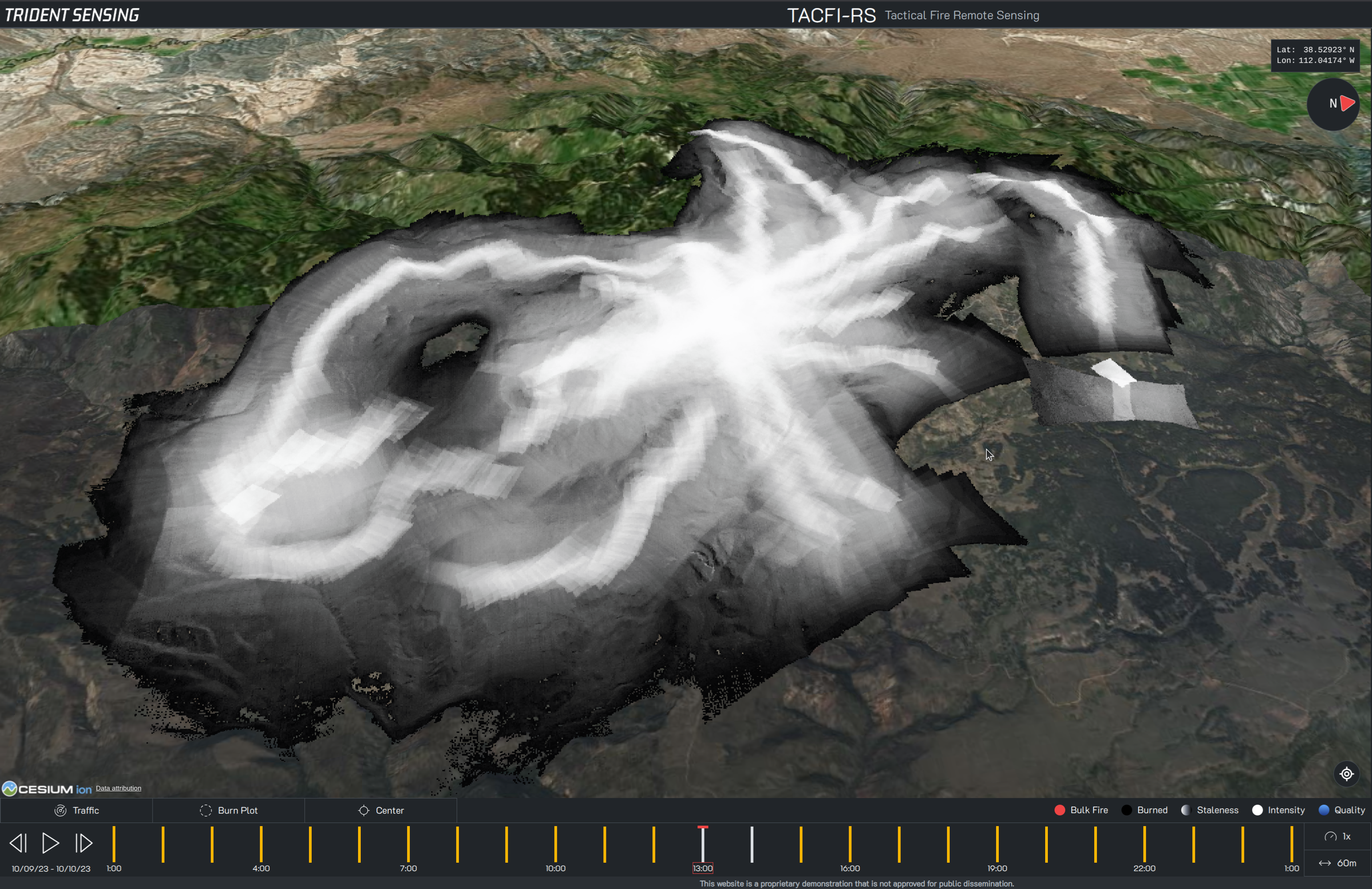
3D Viewer
Visualize fire on accurate terrain.
TACFI-RS renders everything in 3D, utilizing real terrain maps and satellite imagery layers. Understand the geometry of the incident, and upload custom imagery layers for even more situational awareness.
Global Data
View fires around the world.
Every part of the system was designed for global data collection. View the combined data of all sensors in your fleet, on one single map. Even if you operate in Alaska and Australia.
Intuitive Data
Intensity
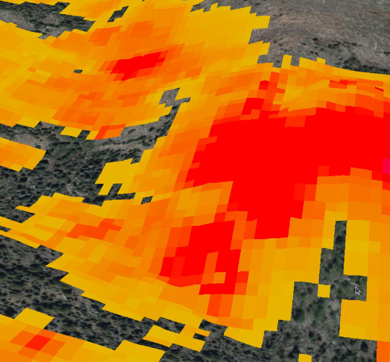
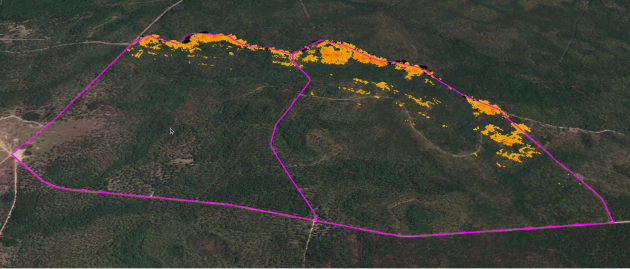
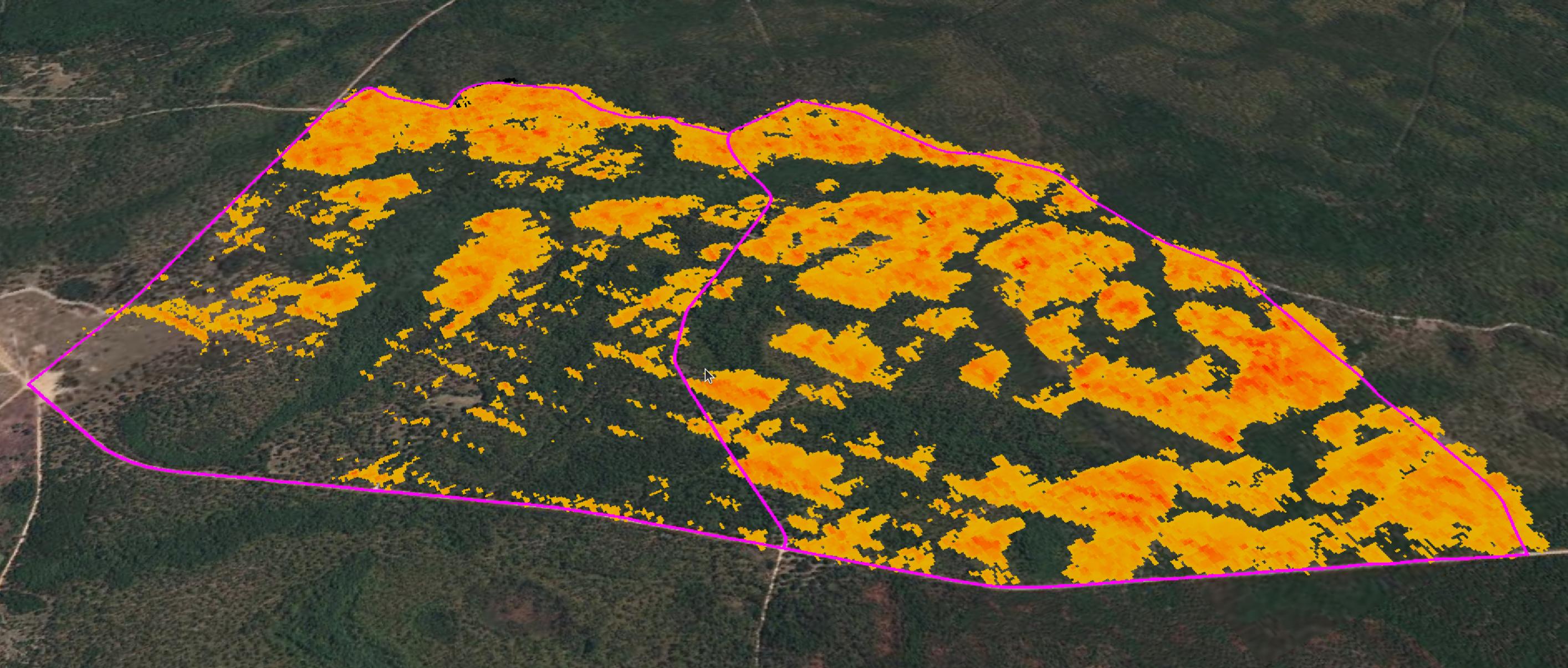
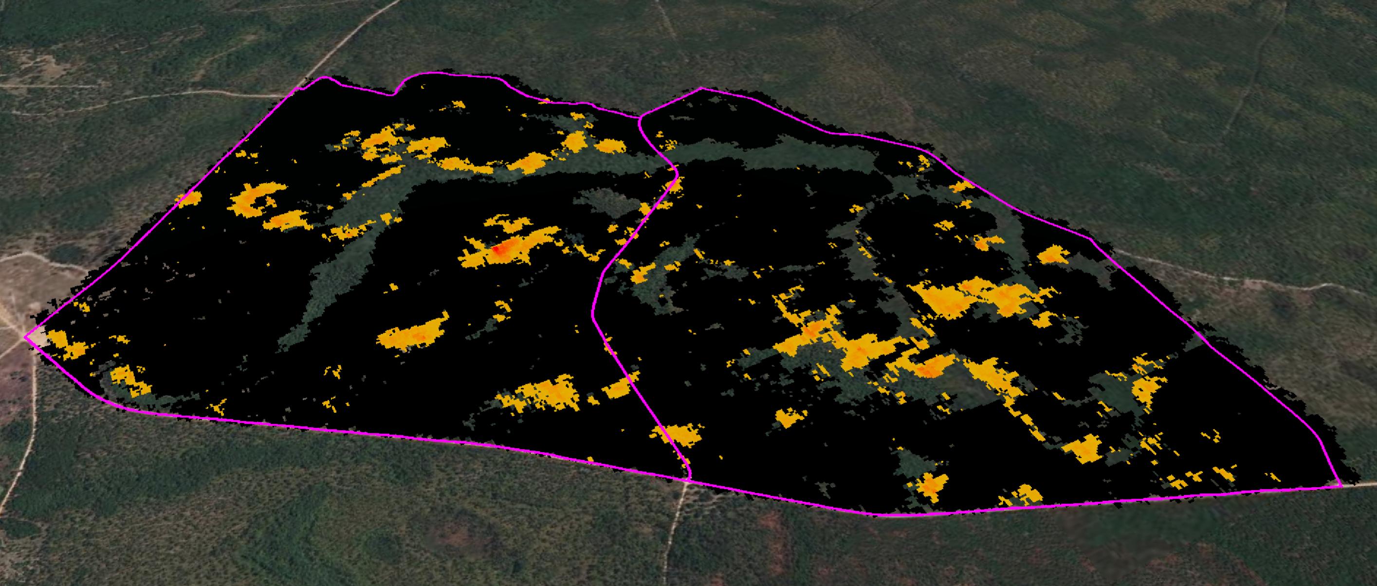
Fire intensity is easily seen using a color gradient. Lower intensity fire is shown in yellow, while higher intensity fire is shown in red. Automated classification provides precise and real-time detection.
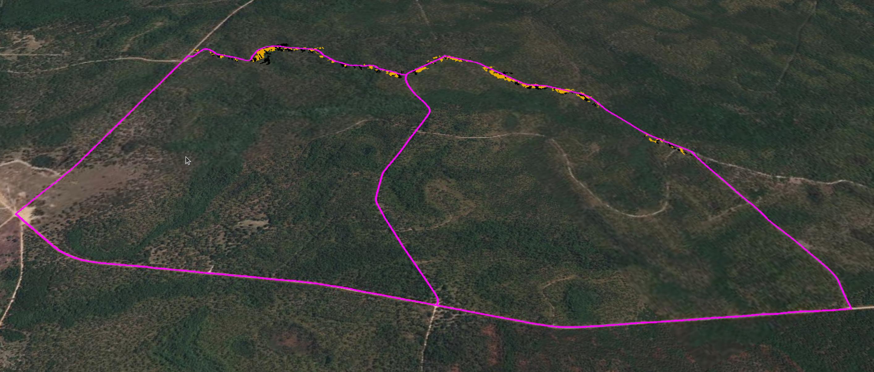
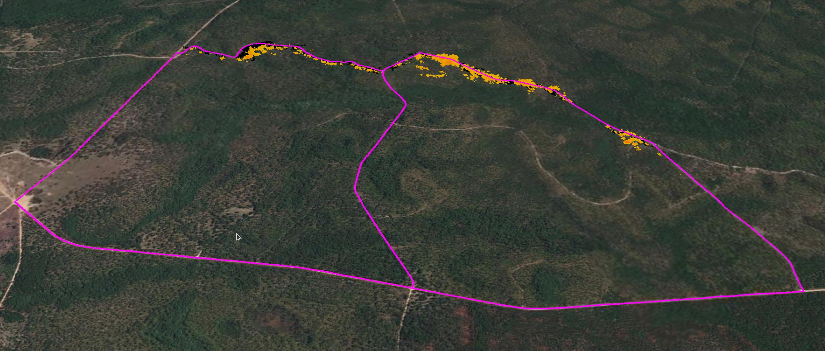
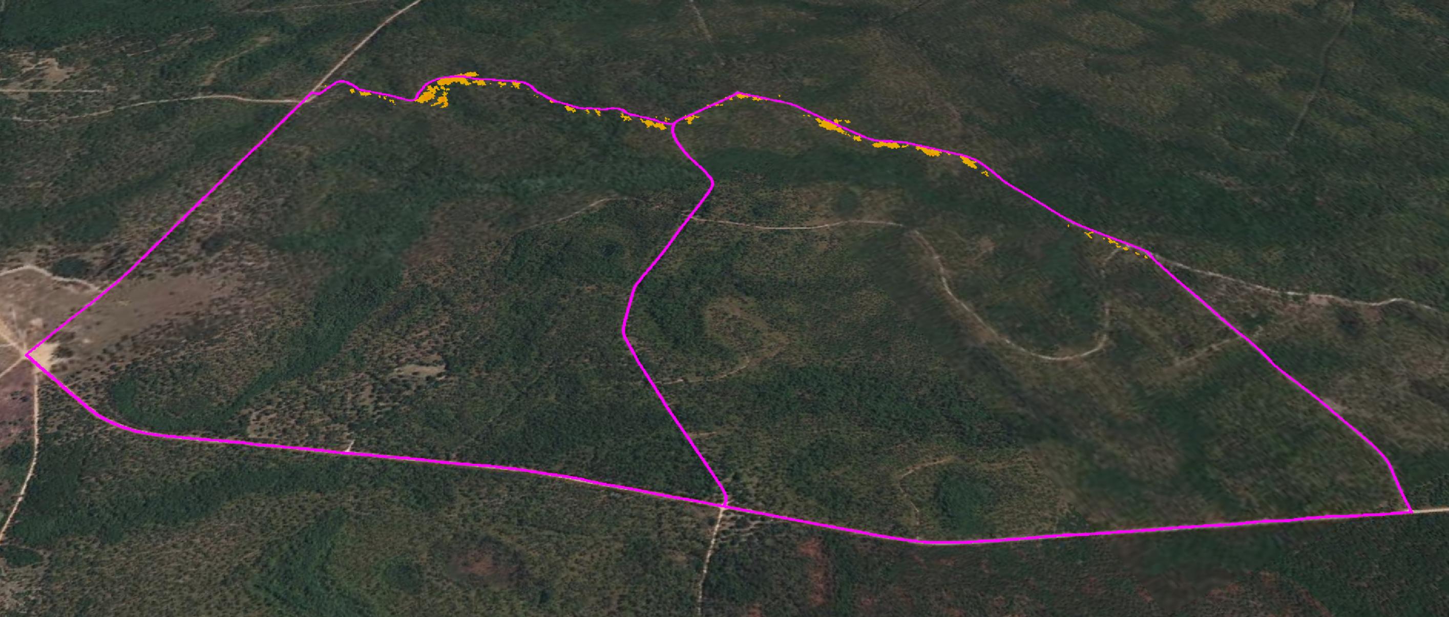
Coverage
Easily see what areas have been imaged and which are in the dark using coverage maps. Fly organic flight paths and supplement blind spots with deviation as needed.
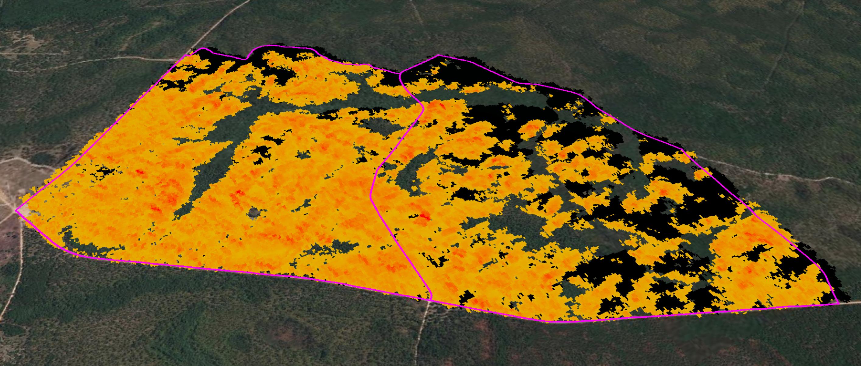
Burned
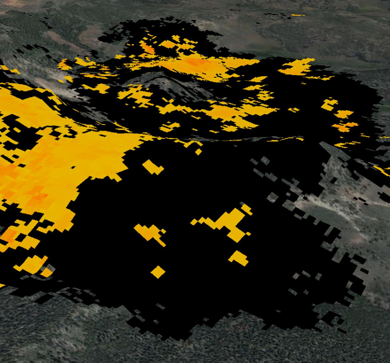
With time-aware imagery, TACFI-RS tells you which areas have never burned (transparent), are currently burning (gradient), and have burned out (black).
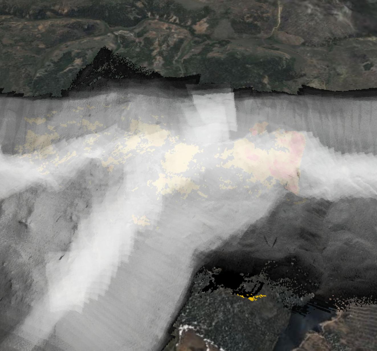
Raw LWIR
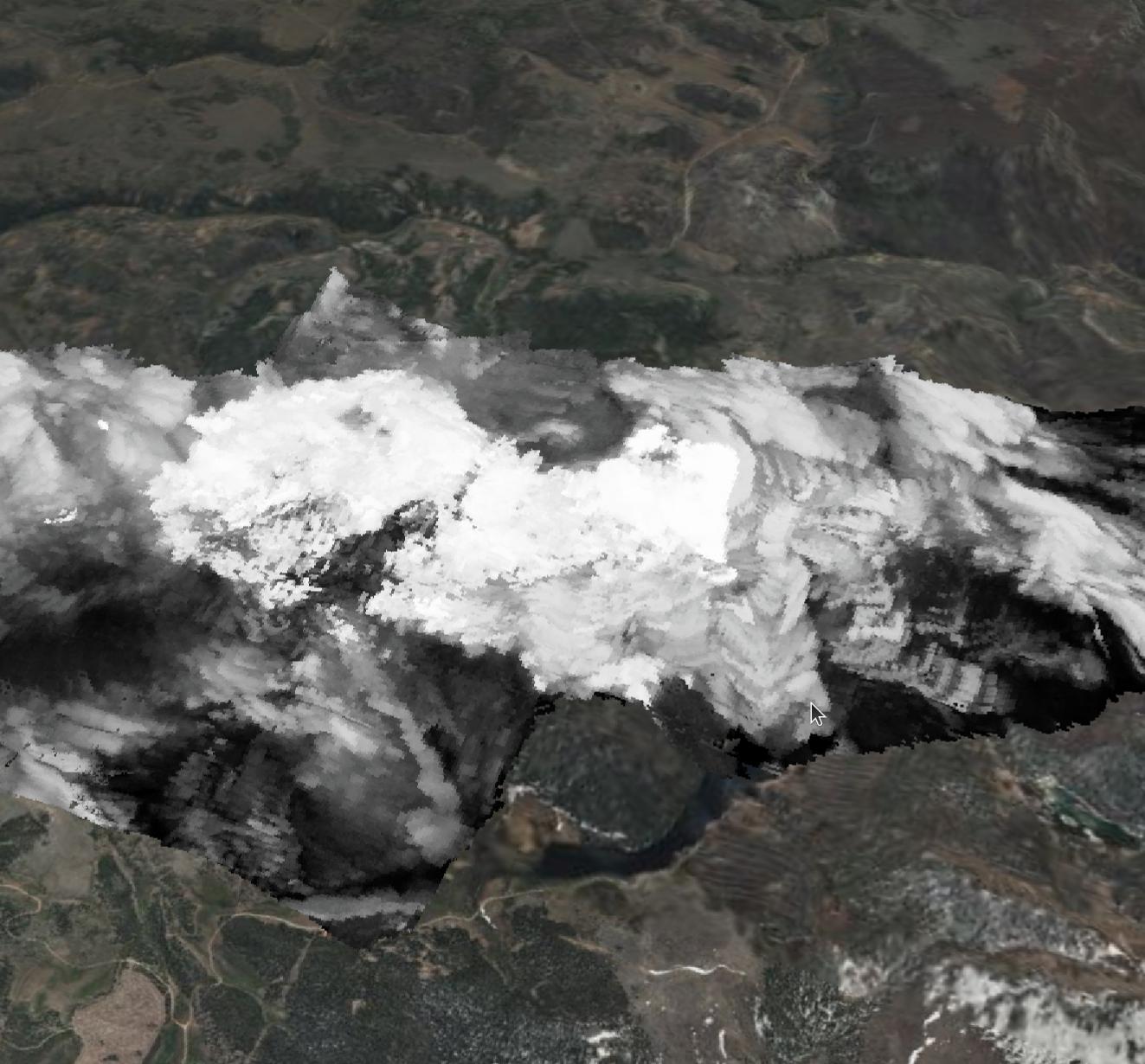
Raw LWIR intensity data is available for direct viewing, and powering downstream technologies such as advanced predictive models.
See more of the fire.
Precise Imaging
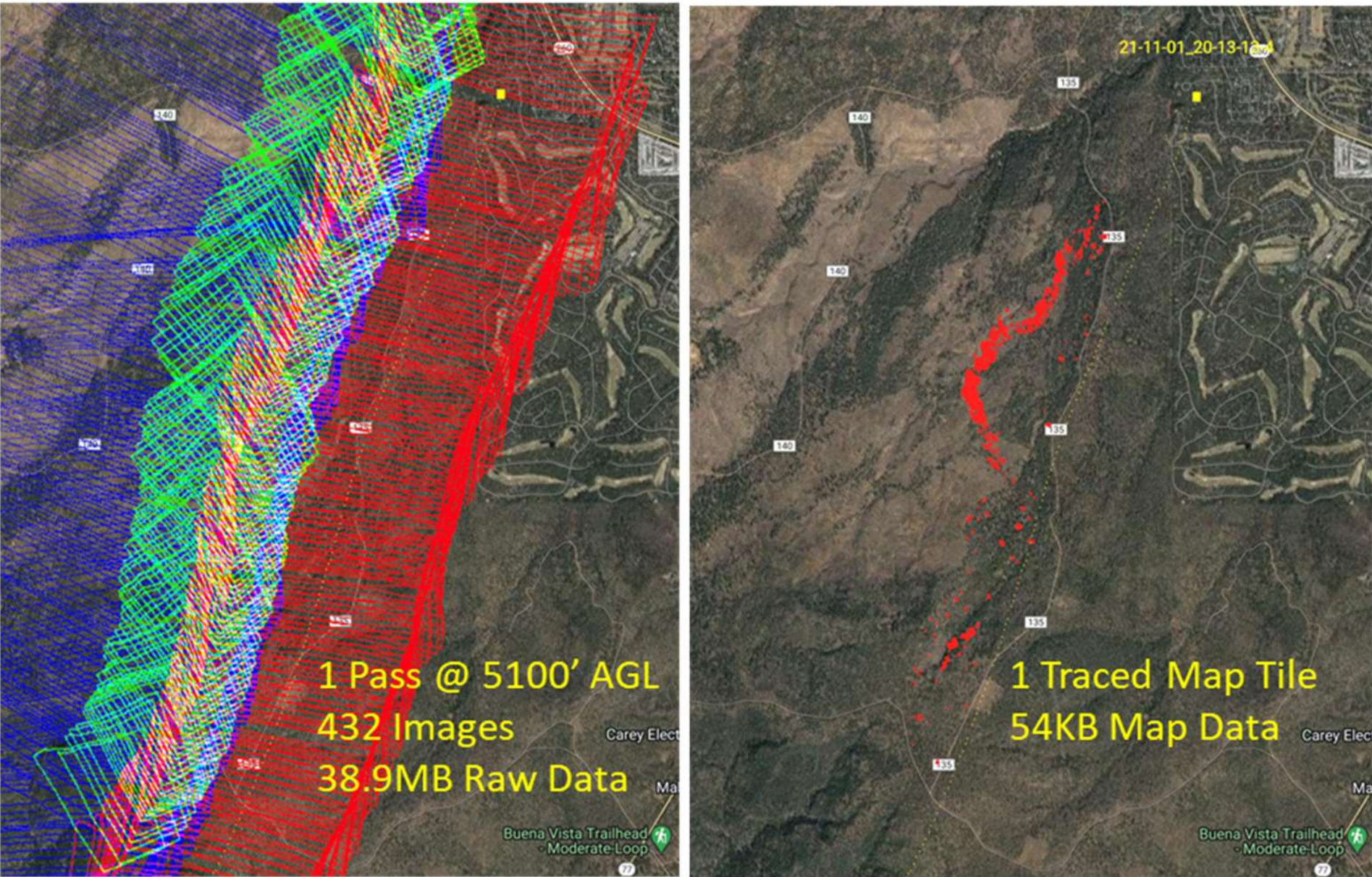
TACFI-RS geolocates every sample and automatically characterizes fire intensity, providing vastly improved fidelity over existing satellite systems. By compressing all data to a common 10 meter grid, TACFI-RS allows for real-time transmission of data over narrow datalinks.
Combine Data from All Sensors

Combined Coverage
TACFI-RS automatically combines the imagery from all sensors in real-time to produce a single map, giving you combined coverage from all aircraft.
Fly Any Path
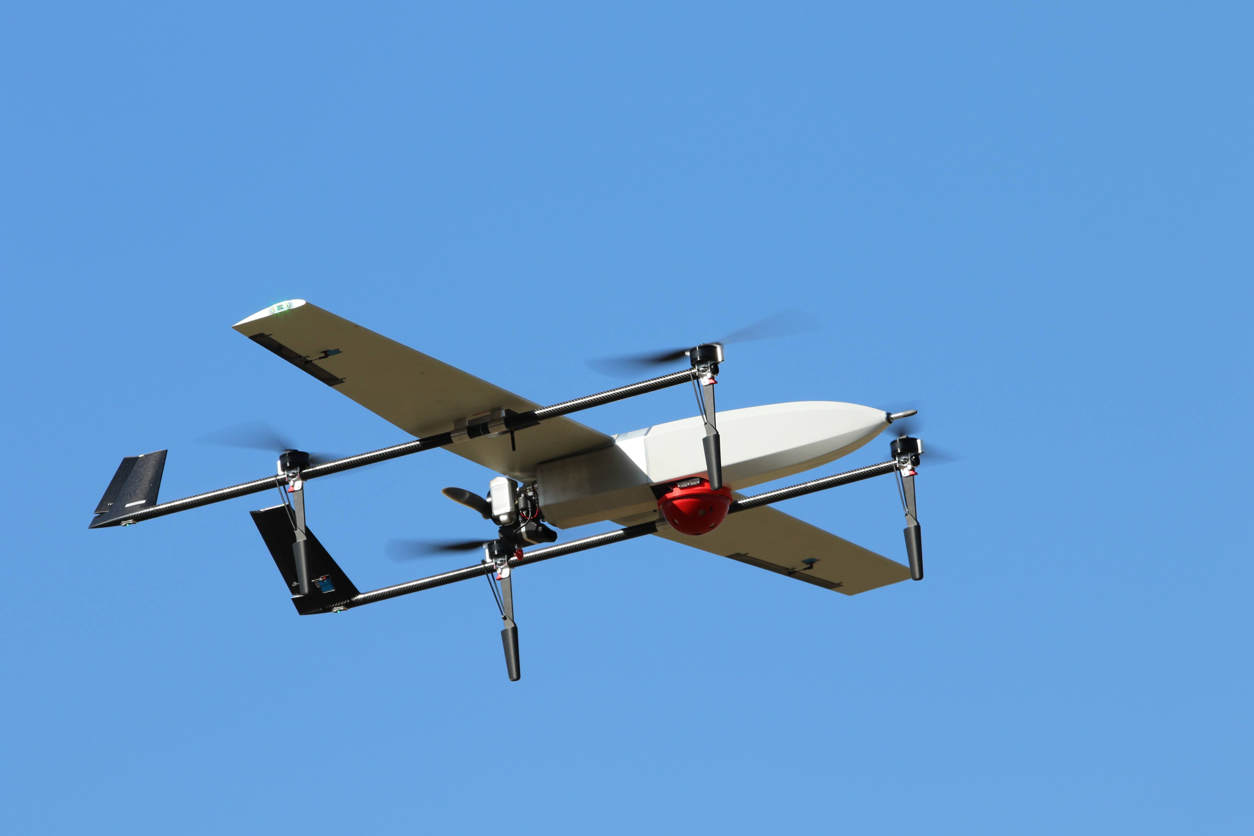
TACFI-RS can gather imagery from a wide range of altitudes, flying any path. This means you can install the system on aircraft doing other missions, such as retardant drops or cargo movement, and automatically collect mapping data with no changes to your flight planning.

Show the Best Quality
As sensors collect readings, extra information such as turbulence, altitude, and other metrics are recorded. Our patent pending method then uses this information to provide the user a single, high quality map, distilled from all available sensors.
Pilot Proof

TACFI-RS utilizes a pilot-friendly on-off switch to control operation.
- No crew station.
- Fly existing flight plans and collect useful data.
- “Parasitic mission” - TACFI-RS is designed to be an addition to aircraft already operating on the fire, not another dedicated sensor platform.
Optionally, a tablet can be connected to the local network inside the aircraft to view more sensor data:
- Livestream thermal camera feeds for better situational awareness.
- View live-updating fire maps generated by your aircraft.
- Manually send map data to the cloud for immediate transmission, reducing latency when important imagery is collected.
Adjustable Timescales
See small changes, or large trends.
5 Minute Timescale

0-5 minutes
5-10 minutes
10-15 minutes
15-20 minutes
60 Minute Timescale
0-60 minutes
60-120 minutes
120-180 minutes
180-240 minutes
TACFI-RS allows you to easily select the “timescale” (duration) that each map occupies. Timescales go down to 5 minutes, letting you see small movements in the fire, while longer timescales such as 60 minutes or daily lets you see broader trends.

Low Bandwidth
Edge Processing Enables Compression
Utilizing onboard compute, TACFI-RS takes thousands of images and processes them down to very small packets that are backhauled to the cloud. A single pass of a fire could contain hundreds of megabytes of data, but yield a transmission that is only kilobytes.

Low Bandwidth
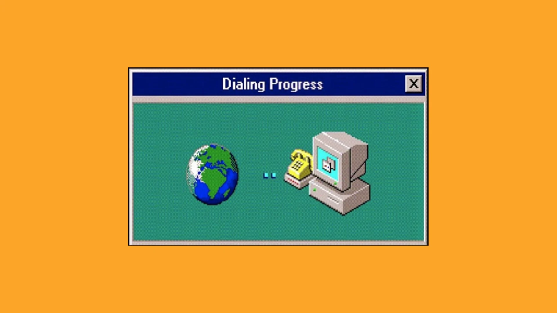
TACFI-RS was desigined to be used with satellite links as slow as dial-up.
Use any Datalink
TACFI-RS is equipped with an ethernet jack to utilize any networking already onboard the aircraft. As long as the system can route to our cloud processing, it is connection-agnostic. Below are some links we have used in the past:
- Iridium Certus: TACFI-RS has been tested extensively with Iridium Certus modems, providing a low SWAP global backhaul.
- Cellular: When coverage is available, cell modems are one of the cheapest, fastest options available. TACFI-RS mini has a built-in modem for this purpose.
- Starlink: Complete overkill for TACFI-RS basic functionality, however increased bandwidth allows for much faster downlinking of data, increased update rates, and more.
- No datalink: TACFI-RS automatically queues data sending until a connection is available. It is possible to connect TACFI-RS to WiFi at a hangar, and update the data during refueling.

Flies on Everything
Three Sensor Designs
TACFI-RS
(0-8000’ AGL)
Expand

TACFI-RS Mini
(0-3000’ AGL)
Coming Soon
TACFI-RS HA
(6-50k’ AGL)
Coming Soon - 2026
Case Studies
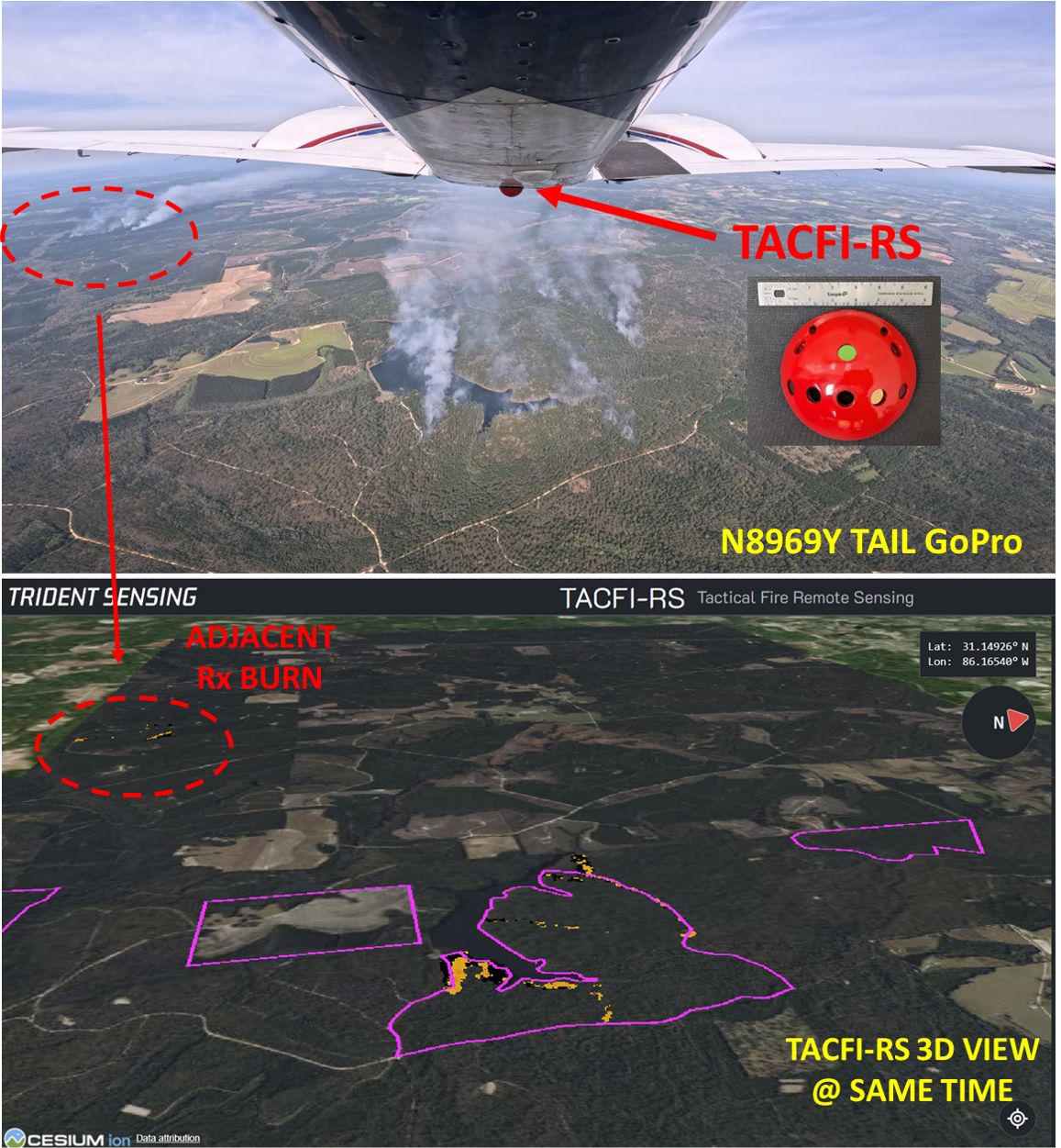
TACFI-RS was flown for NASA’s FIRESENSE campaign during the spring season of 2025. During this campaign, sensors were flown on Trident Sensing’s PA-39 twin commanche, as well as NASA’s Supervolo XL. Multiple prescribed burns were imaged, including Geneva State Lake, Alabama as well as Ft. Stewart Georgia.
Contact Us
To purchase, schedule a demo, or receive more information, send us an email!
tacfi-rs@tridentsensing.com
© Trident Sensing Inc.
2025
All Rights Reserved

Real Time Fire
Moving maps of wildfires - from aircraft to your browser in 5 minutes.
Overview
A complete wildfire mapping system.
TACFI-RS tells you where the fire is, where the fire has been, and where it is going, all within 5 minutes of imaging. Simply fly a TACFI-RS sensor on one or more aircraft, flip the power switch, and view automatically generated maps directly on your browser.
Designed as part of a USDA research grant, TACFI-RS solves many of the problems that have plagued previous wildfire sensing systems. For years, maps have taken hours or days to create, making them less useful for critical decision making. Dedicated aircraft had to be used for sensing, even if other aircraft were already flying over the fire. High expenses reserved sensors for only a handful of aircraft nationally, leading to a scarcity of data for all but the most important fires. TACFI-RS was designed ground-up to be different: real-time, collaborative, and ubiquitous.
Patent Pending.

Time-Based Maps
See where the fire has been, anticipate where it’s going.
Just like a weather radar, TACFI-RS creates maps every 5 minutes and displays them using an intuitive timeline.

Real-Time
TACFI-RS sends new data from sensors to users every 5 minutes. That means fire maps are recent, usable, and accurate.
3D Viewer
Visualize fire on accurate terrain.
TACFI-RS renders everything in 3D, utilizing real terrain maps and satellite imagery layers. Understand the geometry of the incident, and upload custom imagery layers for even more situational awareness.
Global Data
View fires around the world.
Every part of the system was designed for global data collection. View the combined data of all sensors in your fleet, on one single map. Even if you operate in Alaska and Australia.
Intuitive Data
Fire Intensity
Fire intensity is easily seen using a color gradient. Lower intensity fire is shown in yellow, while higher intensity fire is shown in red. Automated classification provides precise and real-time detection.
Coverage
Easily see what areas have been imaged and which are in the dark using coverage maps. Fly organic flight paths and supplement blind spots with deviation as needed.
Burned Detection
With time-aware imagery, TACFI-RS tells you which areas have never burned (transparent), are currently burning (gradient), and have burned out (black).
Raw LWIR
Raw LWIR intensity data is available for direct viewing, and powering downstream technologies such as advanced predictive models.
See more of the fire.
Precise Imaging
TACFI-RS geolocates every sample and automatically characterizes fire intensity, providing vastly improved fidelity over existing satellite systems. By compressing all data to a common 10 meter grid, TACFI-RS allows for real-time transmission of data over narrow datalinks.
Combine Data from All Sensors
Combined Coverage
TACFI-RS automatically combines the imagery from all sensors in real-time to produce a single map, giving you combined coverage from all aircraft.
Fly Any Path
TACFI-RS can gather imagery from a wide range of altitudes, flying any path. This means you can install the system on aircraft doing other missions, such as retardant drops or cargo movement, and automatically collect mapping data with no changes to your flight planning.
Show the Best Quality
As sensors collect readings, extra information such as turbulence, altitude, and other metrics are recorded. Our patent pending method then uses this information to provide the user a single, high quality map, distilled from all available sensors.
Pilot Proof
TACFI-RS utilizes a pilot-friendly on-off switch to control operation.
- No crew station.
- Fly existing flight plans and collect useful data.
- “Parasitic mission” - TACFI-RS is designed to be an addition to aircraft already operating on the fire, not another dedicated sensor platform.
Optionally, a tablet can be connected to the local network inside the aircraft to view more sensor data:
- Livestream thermal camera feeds for better situational awareness.
- View live-updating fire maps generated by your aircraft.
- Manually send map data to the cloud for immediate transmission, reducing latency when important imagery is collected.
Adjustable Timescales
See small changes, or large trends.
5 Minute Timescale
0-5 minutes
5-10 minutes
10-15 minutes

15-20 minutes
60 Minute Timescale
0-60 minutes
60-120 minutes
120-180 minutes
180-240 minutes
TACFI-RS allows you to easily select the “timescale” (duration) that each map occupies. Timescales go down to 5 minutes, letting you see small movements in the fire, while longer timescales such as 60 minutes or daily lets you see broader trends.

Low Bandwidth
Edge Processing Enables Compression
Utilizing onboard compute, TACFI-RS takes thousands of images and processes them down to very small packets that are backhauled to the cloud. A single pass of a fire could contain hundreds of megabytes of data, but yield a transmission that is only kilobytes.
Low Bandwidth
TACFI-RS was desigined to be used with satellite links as slow as dial-up.
Use any Datalink
TACFI-RS is equipped with an ethernet jack to utilize any networking already onboard the aircraft. As long as the system can route to our cloud processing, it is connection-agnostic. Below are some links we have used in the past:
- Iridium Certus: TACFI-RS has been tested extensively with Iridium Certus modems, providing a low SWAP global backhaul.
- Cellular: When coverage is available, cell modems are one of the cheapest, fastest options available. TACFI-RS mini has a built-in modem for this purpose.
- Starlink: Complete overkill for TACFI-RS basic functionality, however increased bandwidth allows for much faster downlinking of data, increased update rates, and more.
- No datalink: TACFI-RS automatically queues data sending until a connection is available. It is possible to connect TACFI-RS to WiFi at a hangar, and update the data during refueling.

Flies on Everything
Three Sensor Designs
TACFI-RS
(0-8000’ AGL)
Expand
TACFI-RS Mini
(0-3000’ AGL)
Coming Soon
TACFI-RS HA
(6-50k’ AGL)
Coming Soon - 2026
Case Studies
TACFI-RS was flown for NASA’s FIRESENSE campaign during the spring season of 2025. During this campaign, sensors were flown on Trident Sensing’s PA-39 twin commanche, as well as NASA’s Supervolo XL. Multiple prescribed burns were imaged, including Geneva State Lake, Alabama as well as Ft. Stewart Georgia.
Contact Us
To purchase, schedule a demo, or receive more information, send us an email!
tacfi-rs@tridentsensing.com
© Trident Sensing Inc.
2025
All Rights Reserved

Real Time Fire
Moving maps of wildfires - from aircraft to your browser in 5 minutes.
Try the Demo
Contact for Purchasing
Overview
A complete wildfire mapping system.
TACFI-RS tells you where the fire is, where the fire has been, and where it is going, all within 5 minutes of imaging. Simply fly a TACFI-RS sensor on one or more aircraft, flip the power switch, and view automatically generated maps directly on your browser.
Designed as part of a USDA research grant, TACFI-RS solves many of the problems that have plagued previous wildfire sensing systems. For years, maps have taken hours or days to create, making them less useful for critical decision making. Dedicated aircraft had to be used for sensing, even if other aircraft were already flying over the fire. High expenses reserved sensors for only a handful of aircraft nationally, leading to a scarcity of data for all but the most important fires. TACFI-RS was designed ground-up to be different: real-time, collaborative, and ubiquitous.
Patent Pending.

Time-Based Maps
See where the fire has been, anticipate where it’s going.
Just like a weather radar, TACFI-RS creates maps every 5 minutes and displays them using an intuitive timeline.

Real-Time
TACFI-RS sends new data from sensors to users every 5 minutes. That means fire maps are recent, usable, and accurate.
3D Viewer
Visualize fire on accurate terrain.
TACFI-RS renders everything in 3D, utilizing real terrain maps and satellite imagery layers. Understand the geometry of the incident, and upload custom imagery layers for even more situational awareness.
Global Data
View fires around the world.
Every part of the system was designed for global data collection. View the combined data of all sensors in your fleet, on one single map. Even if you operate in Alaska and Australia.
Precise Imaging
See more of the fire.
TACFI-RS geolocates every sample and automatically characterizes fire intensity, providing vastly improved fidelity over existing satellite systems. By compressing all data to a common 10 meter grid, TACFI-RS allows for real-time transmission of data over narrow datalinks.
Intuitive Data
Fire Intensity
Fire intensity is easily seen using a color gradient. Lower intensity fire is shown in yellow, while higher intensity fire is shown in red. Automated classification provides precise and real-time detection.
Coverage
Easily see what areas have been imaged and which are in the dark using coverage maps. Fly organic flight paths and supplement blind spots with deviation as needed.
Burned Detection
With time-aware imagery, TACFI-RS tells you which areas have never burned (transparent), are currently burning (gradient), and have burned out (black).
Raw LWIR
Raw LWIR intensity data is available for direct viewing, and powering downstream technologies such as advanced predictive models.
Combine Data from All Sensors
Combined Coverage
TACFI-RS automatically combines the imagery from all sensors in real-time to produce a single map, giving you combined coverage from all aircraft.
Fly Any Path
TACFI-RS can gather imagery from a wide range of altitudes, flying any path. This means you can install the system on aircraft doing other missions, such as retardant drops or cargo movement, and automatically collect mapping data with no changes to your flight planning.
Show the Best Quality
As sensors collect readings, extra information such as turbulence, altitude, and other metrics are recorded. Our patent pending method then uses this information to provide the user a single, high quality map, distilled from all available sensors.
Pilot Proof
TACFI-RS utilizes a pilot-friendly on-off switch to control operation.
- No crew station.
- Fly existing flight plans and collect useful data.
- “Parasitic mission” - TACFI-RS is designed to be an addition to aircraft already operating on the fire, not another dedicated sensor platform.
Optionally, a tablet can be connected to the local network inside the aircraft to view more sensor data:
- Livestream thermal camera feeds for better situational awareness.
- View live-updating fire maps generated by your aircraft.
- Manually send map data to the cloud for immediate transmission, reducing latency when important imagery is collected.
Adjustable Timescales
See small changes, or large trends.
5 Minute Timescale
0-5 minutes
5-10 minutes
10-15 minutes

15-20 minutes
60 Minute Timescale
0-60 minutes
60-120 minutes
120-180 minutes
180-240 minutes
TACFI-RS allows you to easily select the “timescale” (duration) that each map occupies. Timescales go down to 5 minutes, letting you see small movements in the fire, while longer timescales such as 60 minutes or daily lets you see broader trends.

Low Bandwidth
Edge Processing Enables Compression
Utilizing onboard compute, TACFI-RS takes thousands of images and processes them down to very small packets that are backhauled to the cloud. A single pass of a fire could contain hundreds of megabytes of data, but yield a transmission that is only kilobytes.
Low Bandwidth
TACFI-RS was desigined to be used with satellite links as slow as dial-up.
Use any Datalink
TACFI-RS is equipped with an ethernet jack to utilize any networking already onboard the aircraft. As long as the system can route to our cloud processing, it is connection-agnostic. Below are some links we have used in the past:
- Iridium Certus: TACFI-RS has been tested extensively with Iridium Certus modems, providing a low SWAP global backhaul.
- Cellular: When coverage is available, cell modems are one of the cheapest, fastest options available. TACFI-RS mini has a built-in modem for this purpose.
- Starlink: Complete overkill for TACFI-RS basic functionality, however increased bandwidth allows for much faster downlinking of data, increased update rates, and more.
- No datalink: TACFI-RS automatically queues data sending until a connection is available. It is possible to connect TACFI-RS to WiFi at a hangar, and update the data during refueling.
Flies on Everything
Three Sensor Designs
TACFI-RS
(0-8000’ AGL)
Expand
TACFI-RS Mini
(0-3000’ AGL)
Coming Soon
TACFI-RS HA
(6-50k’ AGL)
Coming Soon - 2026
Case Studies
TACFI-RS was flown for NASA’s FIRESENSE campaign during the spring season of 2025. During this campaign, sensors were flown on Trident Sensing’s PA-39 twin commanche, as well as NASA’s Supervolo XL. Multiple prescribed burns were imaged, including Geneva State Lake, Alabama as well as Ft. Stewart Georgia.
Contact Us
To purchase, schedule a demo, or receive more information, send us an email!
tacfi-rs@tridentsensing.com
© Trident Sensing Inc.
2025
All Rights Reserved